If you are looking for information about the Prokletije National Park, or you are a hikers, you are in the right place. This amazing place is located in the north of Montenegro and next to the Durmitor National Park is considered one of the most attractive for hikers. It is also the youngest protected area in this country. It is located between Montenegro, Albania, and Kosovo and covers an area of 16,630 hectares. One of the highest peaks of the Prokletije National Park is Zla Kolata (2534) and it is also the highest peak in Montenegro. Winters here are harsh and long, and summers are fresh and short. Average annual air temperatures of 2-7 ° C. The maximum amount of precipitation is excreted in late autumn and the first part of winter. The snow cover is on average 15 cm thick and lasts from 90 to 210 days.
The source-Oko Skakavice
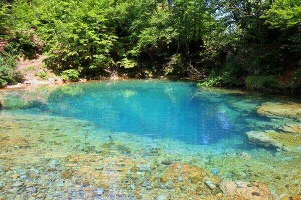
Sights of the national park Prokletije
The biggest sights of the national park Prokletije are Hrid and Visitor Lake. Hridsko Lake is located at 1970 meters above sea level and is one of the most beautiful in Montenegro. The area is about 35000m, and the maximum depth is 4m. Visitor Lake has been at an altitude of 1820 and is one of the highest in our country. It is especially special for the small floating island that is moving. In addition to these lakes in the national park you can visit Koljindarsko, Ropojansko, Tatarijsko, Bjelaj, Vezirova brada and the lake on Treskavac. This area is also known for its extremely rich flora and fauna.
Mountains and hiking trails
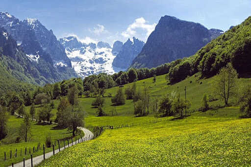
The mountains and hiking trails are what make this national park recognizable. Besides Zla Kolata, the largest peaks are Karanfil (2480), Koplje (2200), and Ocnjak (2136), which rise above the Grebaja valley, as well as Rosni vrh-Maja (2524) and Kolac-Kolata, which rise above the Rapaja valley. These peaks are very inaccessible and a great challenge for all hikers. Somewhat easier peaks to conquer are Volusnica (1879), Talijanka (2046), and Popadija (2057).
Spring in Prokletije national park
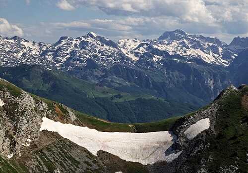
One of the popular hiking trails is Grebaja-Talijanka-Volusnica-Grebaja. It is necessary to go to Carnation in the afternoon because then the sun crosses behind the mountain and the clouds part. Another beautiful hiking trail is Ropojana-Karaula Zastan - Lake Valley - Cafa Jezerce and back. The Ropojan valley can also be reached by off-road vehicle because the road is quite bad. One of the most difficult routes is the hiking trail Grebaja-Krosnjin pass-Sjeverni vrh-Krosnjin pass-Suplja vrata-Grebaja. Only experienced mountaineers can move in this direction. Cables have been installed through Krosnja's passage, which facilitates the ascent in this part. On the way back from the northern peak, you pass through a natural attraction - the Hollow Gate.
Information for hikers
Information for hikers: hiking trails marked, but it is still not recommended to hike without the advice or company of one of the experienced guides. There are three active mountaineering clubs in Plav. Their guides can guide you through these areas and help if you want to conquer a mountain peak. They can also find your accommodation in mountain lodges and cottages. For fans of free climbing, there are five landscaped terrains, as well as many hiking trails. If you are a fan of outdoor activities, Montenegro offers many opportunities for active holidays.
Grebaja Valley
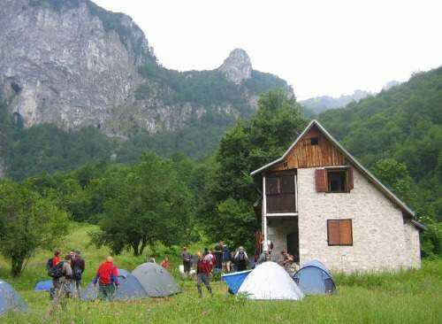
The starting point for all hiking trips is the Grebaja valley, which is 7 km away from Gusinje. Two mountain lodges are open to all visitors.
Ropojana Valley
The Ropojana Valley is located on the border with Albania. The marked path to the highest peak of Prokletije, Maja Jezerce, starts from it. Especially interesting and demanding is the traditional ascent to Maja Jezerce (the highest peak of Prokletije), which is held every year in March. The climb starts around 2 am and lasts over 10 am. Mountaineers from Montenegro, Serbia, Bosnia, and Herzegovina, and Kosovo are participating, and usually only half manage to reach the top due to heavy snow and difficult climbing conditions.
Valley Ropojana
Waterfalls of the river Grlja
The river Grlja flows through the national park and broke through its canyon. Along its length, it forms five waterfalls, the first of which is at the entrance to the Skakavica canyon and is 15 meters high. In addition to the previously mentioned lakes, at the foot of Prokletije is Plavsko Lake, which is also the largest in this national park. It is about 2 kilometers long, while it is about 1 kilometer wide. The Lim River springs from it. The Lim River is rich in fish, and you can get a fishing license by contacting your local fishing club.
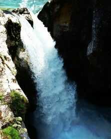
Waterfall of the river Grlja
Frequently asked questions for Prokletije National Park
How much is a ticket?
- Ticket for 1 day per person, including a visit to the Visitor Center is 1 euro.
- Bicycle rental is 3 euros per hour
- Use of guide services 40 euros for 4 hours.
- Rent a snowshoe 4 euros for 1 day.
- Rent hiking poles 3 euros for 1 day
- Rent a tent 8 euros for 1 day.
- Use of tent space 3 euros for 1 day
- Use of arranged camping spaces 10 euros for 1 day.
You can also find all the information on the website of the national parks of Montenegro.
How to get to this region?
By bus
The bus from Podgorica to Plav can be reached in the direction: Podgorica-Kolasin-Andrijevica-Plav. The trip takes about 3:45, and a one-way ticket is 12 euros.
Rent a car
If you decide to rent a car in Montenegro than rental trip takes just under 3 hours. You can also use the road Podgorica-Mojkovac-Berane-Andrijevica-Plav.
How do you get into a national park?
The national park does not have the main entrance. Toll booths exist in Grebaj valley, Ropojani-Gusinje, and Gradine-Plav.
Where to stay?
You can stay in Plav, where the Plav Lake Hotel is located, and in Gusinje, the Rosi Hotel. In the village of Vusanje near Gusinje there is an eco katun Rosi, then an eco-camp Bektesevic. In the center of the park is Bajrovica katun, where Samel's hut is open from June to October. In the Grebaja valley, there are several small rural households and hotels where you can sleep and eat. There is also a mountain lodge here, where you can also look for accommodation, especially if you are not moving to high comfort.
Valley Grebaja-mountain lodge
Is there a signal for telephone and internet?
The signal for telephone and internet exists in most of the area. A phone is needed when embarking on this endeavor. It is needed because of the connection with the outside world, photography, but also because of the orientation using Google Maps. Of course, there are always pockets that are not covered by the signal.
When is the best time to visit Prokletije National Park?
The best time to visit the Prokletije National Park is in June. Already at the end of June, many lakes begin to disappear, and as time goes on, drought sets in. In late spring, everything is still green, water sources are still rich, and the plant world is at the peak of development. You can visit this area later in the summer, until the fall. During the winter, a visit is not recommended, due to extremely low temperatures and heavy snow. There are no ski resorts or hotel centers here that work during the winter.
Plav and Gusinje
Plav and Gusinje are larger populated places where you can stay and get necessities for yourself. Plav has about 3500 inhabitants who are mainly engaged in agriculture and livestock. In blue, there are two banks, the first bank, and CKB. There are also several car mechanics and vulcanization shops in the city. You can also find a gas station. If you have rented a car and want to visit these areas, make sure that the nearest gas station is in Andrijevica.
Famous festivals in this area are blueberry days in early August, as well as diaspora days in late July. During this period, as part of the Gusinje summer, numerous cultural and entertainment events are held that promote the nature, cuisine, and traditions of these areas.